CH 1 THE EARTH
Learning Objectives:
- Students will be able to define the latitudes and longitudes.
- Students will be able to define Equator and Prime meridian.
- Students will be able to differentiate between latitudes and longitudes, equator and
prime meridian, prime meridian and International Date Line.
- Students will be able to locate cities with the help of latitudes and longitudes on the atlas.
- Students will be able to locate the places on the four directional grid.
- Students will be able to locate places on the two directional grid.
- Students will be able to calculate the time difference of two places based on the Meridians.
- Students will be able to define International Date Line.
- Students will be able to state the importance of International Date Line.
- Students will be able to write and include the geographical terminologies in their answers.
The Earth
The earth is a solid body made up of land and water. It is spherical in shape, but not a perfect sphere. It is like an orange – slightly flat at the two ends.
Long ago everyone actually believed that the Earth was flat. They believed that if we travelled to the edges, we would fall off! About 400 years ago the explorer Magellan sailed westwards. After three years his ship returned to the same point. The ship had sailed around the world, and proved that the Earth is round. Today we know for sure that the Earth is round.
Photographs of the Earth taken from space show that the Earth is round – just like the moon or the sun. The Earth appears flat to us because of its large size, as compared to the distance we can see.
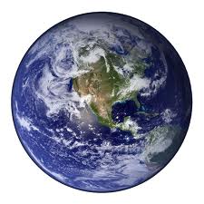
The Globe
The globe is a small model of Earth. It shows us the shape and location of the continents, oceans and seas on a smaller scale. It also shows the shape and location of countries, and the location of important cities.
You can see only half the globe at one time. However, you can turn the globe around to see the other half. It can be turned around a line passing through it. This line is called the axis. The earth is titled at an angle of 66½ degrees and it rotates on it. The earth also revolves in its orbit around the sun.
The two end points on the axis of rotation are called the poles. To the north is the North Pole, and to the south is the South Pole.

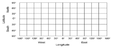
Latitudes are imaginary lines running from east to west on a globe. One such imaginary line of latitude is the equator. It divides the earth into two equal halves known as hemispheres. The northern part of the earth above the equator is known as Northern Hemisphere and the southern part of the earth below the equator is called the Southern Hemisphere. Latitudes are also called parallels of latitude as they run parallel to each other and to the equator.
There are 181 latitudes in all. 90 latitudes in the Northern Hemisphere and 90 latitudes in the Southern Hemisphere. 0⁰ i.e. equator, is the longest latitude.
Latitudes are measured in degrees (⁰). The equator is the 0⁰ latitude. Poles are 90⁰ North and 90⁰ South of the equator. The parallels in the Northern Hemisphere are labeled 10⁰N, 20⁰N and so on. On the other hand, the parallels in the Southern Hemisphere are labeled 10⁰S, 20⁰S and so on. The parallels of latitude closer to the equator are longer than those closer to the poles. In fact, the North and South Poles are not lines at all. They are points! Other than the equator and the poles,
four other important latitudes have been
given different names. They are:

· Tropic of Cancer at 23½⁰ N
· Tropic of Capricorn at 23½⁰ S
· Arctic Circle at 66½⁰ N
· Antarctic Circle at 66½⁰ S
· Tropic of Capricorn at 23½⁰ S
· Arctic Circle at 66½⁰ N
· Antarctic Circle at 66½⁰ S
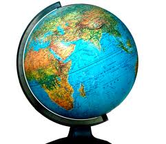
Longitudes are imaginary vertical lines drawn on a globe running from North Pole to South Pole. These are also known as meridians.
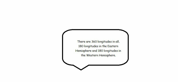
The central longitude that divides the Earth into the Eastern Hemisphere and the Western Hemisphere is known as the Prime Meridian. It is the 0⁰ meridian. This meridian runs through the observatory at Greenwich (pronounced green-ich) in London in the United Kingdom and is also known as the Greenwich Meridian
|
|
|
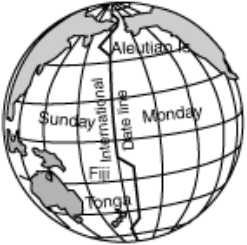
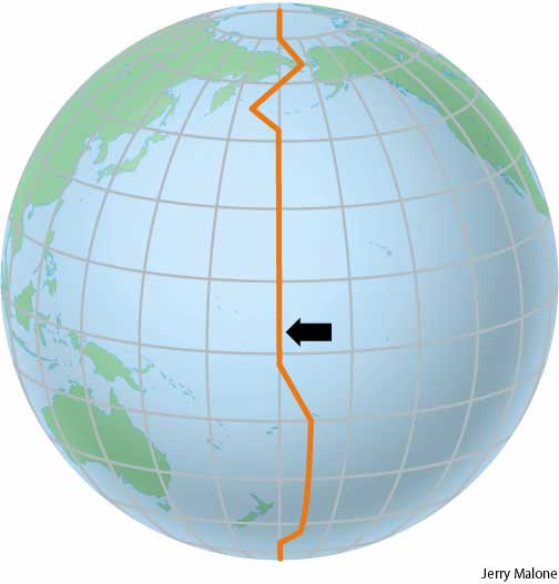
Notice that 180⁰ East or West is half way around the globe. So the 180⁰ East and 180⁰ West longitudes meet and form a single line. This line is known as 180th meridian or International Date Line.
The International Date Line is an irregular line drawn on the map in the Pacific Ocean. The line does not cross land. A new date begins when we cross this meridian. East of the line is one day earlier than to the west. Cross the line from the east to the west and a day is added. Cross from west to the east and a day is subtracted. Here's how the International Date Line works. Let's say you fly from the United States to India. Let's suppose you leave the United States on Tuesday morning. But, once you cross the International Date Line, it's suddenly Wednesday. |
|
On the reverse trip home you fly from India to the United States. You leave India on Monday morning. But once you cross the International Date Line, the day changes to Sunday.
Greenwich Mean Time
The earth takes 24 hours to make one complete rotation. This is equal to one day. The earth rotates from west to east. As the earth rotates, each meridian passes under the direct rays of the sun. It takes 4 minutes for the earth to rotate through 1⁰ of longitude. So when it is sunrise on the eastern side of world, the western side is still in darkness.
The time at Greenwich is observed as the mean time and hence the name Greenwich Mean Time (GMT). All the time throughout the world are compared with the GMT or the 0⁰ longitude. Local time of a particular country can be calculated based on the GMT.
In India we have what is known as Indian Standard Time (IST). This means the whole country keeps the same time.
|
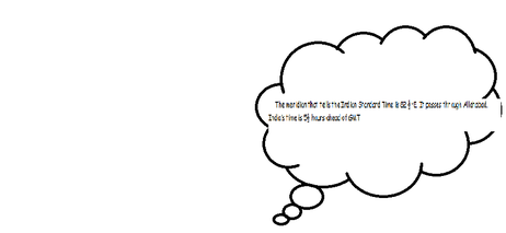
The meridian that tells the Indian Standard Time is 82 ½⁰E. It passes through Allahabad. India’s time is 5½ hours ahead of GMT Calculating Time The longitude of a place is 67.5⁰ E. The time at GMT is 12 noon. Find the time of this place. Time = Longitude of a place × 4 minutes = 67.5 × 4 = 270 minutes i.e. 4.5 hours Since the place is to the east of GMT, so the time will be 4.5 hours ahead of GMT i.e. 16.30 min or 4:30 pm. |
There are two types of grids:
|